Kirsten Anderberg's CA History Site: Santa Clarita Valley, Saugus, Newhall, Castaic, Bouquet Canyon...
Santa Clarita, CA
The Santa Clarita Valley is located within Los Angeles County, to the north of the San Fernando Valley. Prominent cities
in Santa Clarita include Newhall, Castaic, and Saugus. I have lived in the Santa Clarita Valley from 1960 - recently. My first home was in Saugus, CA in 1960. Most recently
I lived in Castaic in 2008. Growing up in this area, I am familiar with its history and its growth since 1960. I am currently a historian working on my Masters
Degree in History, and I find Southern CA history fascinating. On this page are interesting stories from the past, as well as photos, of the Santa Clarita Valley.
The Santa Clarita Valley was all orange groves and farm
fields when we first moved there in 1960. The only roads to the San Fernando Valley were the "Old Road" (the old Highway 99) and San Fernando Road, and San Fernando Road went by one of the oldest
oil refineries in existence. The old days
of Santa Clarita included lots of box turtles walking down newly laid concrete sidewalks in Saugus, and lots of tumbleweed on the Old Road. The old waterfall was not fenced in and my father
and I would climb to the top, it was just a different time...more and more tract homes changed the entire face of the area, along with I-5. Nowadays, the areas by the river beds
have the cheaper apartment
buildings, and flooding still is a threat in the winter. In January of 2008, several areas of Santa Clarita were having issues due to flooding
and I remember some folks saying the local hills were "melting" as that is how it looked, there were mounds of dirt washing onto local roadways all over. And the local washes
that are so dry and empty that they look harmless in summer, were RAGING with water nearly to their banks last winter too! Yet, ironically, fire is the biggest threat to the area.
There are also worries about dams in earthquake country such as the Castaic Dam, Bouquet Canyon Reservoir, Piru, etc.
When I lived in Santa Clarita as a child, it did not seem like a flood plain, but as I have aged, I can clearly see that the Santa Clarita Valley is indeed *a valley* and
valleys are channels that water take to the ocean. And that is what Santa Clarita does at times, it channels huge floods of water down the valley floor to the ocean. The Santa Clarita
Valley experienced a historic dam collapse that ruined Mulholland's career. The water burst forth when the dam broke and went through Santa Clarita to the ocean by Ventura.
There is still evidence of the San Francisquito Dam breakage in the hills of Santa Clarita.
This area has a rich wild west history and also has a lot
of Hollywood history. Many movies have been filmed in the hills of Santa Clarita, you can see it on most any of the old Western movies and TV shows
from the 1950's. It was also used in old Western movies from back in the silent era to date. Part of the reason the film industry chooses to film so often in this area is its
moderate Mediteranean climate and its close proximity to Hollywood...The Santa Clarita Valley was part of the California gold rush, it was an area with a large American Indian population, it had train robberies, and was on the map due to
a train station in Saugus, where Charlie Chaplin is pictured, as a matter of fact. The Santa Clarita Valley was being remade as a bedroom community for Los Angeles when we moved
there in 1960, but it was still incredibly rural, and isolated, in many ways. As kids, we learned about Westerns and Indians, and oil wells, and rattlesnakes...I remember my dad used
to take me looking for trap door spiders in Saugus, and a rattlesnake was coming towards me on the swings in the backyard of our Guadilamar Dr. home when I was about 3 years old
and my dad hacked its head off in front of me with a hoe while yelling at me to get up on the swing with both feet. It was weird but I never forgot it and was aware of snakes ever since.
We also had a lot of tarantulas in Saugus in the 1960's.
SAUGUS:
My dad poses near a Saugus oil pump in the early 1960's...(Photo: Archives of K.Anderberg)
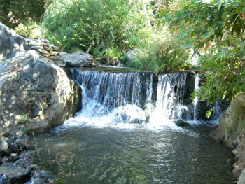
A public waterfall runs year round in Bouquet Canyon, outside Saugus. (Photo: K.Anderberg, August 2008) This is a nice place to visit on a hot summer day, lounging by water
on cool rocks gives a bit of relief from the heat...Read more about the Bouquet Canyon Waterfall...
This photo taken in 1962 shows SNOW in Saugus! Rare indeed, it has only snowed something like three times in the last 100 years there. But I was alive when it
did snow and I made this snowperson on my front lawn, at 22406 Guadilamar Drive, in Saugus, CA. in '62. Notice in the background, the lack of development on the hills where now it
is fully developed. (Photo: Archives of K.Anderberg)
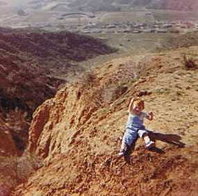
This photo of me when I was a toddler, shows the valley floor of Saugus in the background. This view is looking west, from the hills above Guadilamar Drive.
Note the lack of development at this time in the early 1960's! The elementary school was down below where you see the buildings and I remember seeing a circus down there when
I was only about 3 years old, in approximately 1964. I also remember the "bookmobile" driving up onto Guadilamar Drive regularly during the early 1960's so the kids in that neighborhood could check
out books. You can see how wild the geology in this region is by looking at that hill coming out of the ground to the left in this picture. I believe what is going on there
is that was a steep hillside, and the valley floor filled with sand, etc. and that is how it comes up, flat, to the side of the mountain like that. This area is ridiculously
active geologically with powerful earthquakes that tumble freeway overpasses, such as in both 1971 and 1994 so far, that I have seen. I remember my dad taking me to the
top of that hill on the left and us looking over it to see a raging wildfire coming near our home. I remember my mom being very worried about the fire so close but my
dad found it interesting more than threatening. I do remember them watering down the roof with the hose during the firestorms. (Photo: Archives of K.Anderberg)
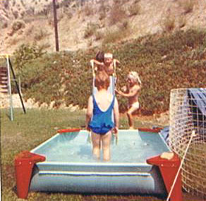
This is a photo of our backyard at 22406 Guadilamar Drive. We had a little pool and all the neighbor kids would come over to swim, but you can see how the hillside
comes right to the back of the house and there is nothing on that hillside. I drove up to see this house in the 1990's and it still is saddled with the hill right behind it and no
development on that hill yet. The houses on the cul-de-sac of Guadilamar Dr. have gone down in quality though. When we lived there in the 1960's, this was the height of
modern living, now it looks more like the street is full of run down houses that have seen better days. We planted the ice plant on the hill to help with erosion control and you can
clearly see where our landscaping begins and the natural habitat resumes. Most of our houses in CA had ice plant on its hills for both erosion and fire suppression, as well as
ice plant being good for water conservation. We had rattlesnakes and other wildlife, such as box turtles, entering our backyard from the hills so close. (Photo: Archives of K.Anderberg)
This is a photo of the first telephone pole above Guadilamar Drive. My father was one of the people who put it up and I remember it was a huge neighborhood celebration the day
it went up! (Photo: Archives of K.Anderberg)
This is a photo of the inside of 22406 Guadilamar Drive in 1962. (Photo: Archives of K.Anderberg)
Oil pumps today are the same as yesterday's, literally...(Photo: K.Anderberg, August 2008)
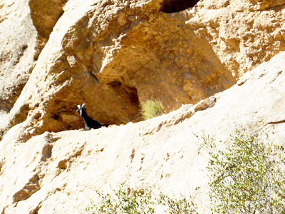
A mountain goat I met in Aug 2008 in Bouquet Canyon (Photo: K.Anderberg, August 2008)
This area has a lot of stage coach history as well, including
Beale's Cut, which was a place where
the stagecoaches came through a slit in the rocks into the Valley.
Placerita Canyon was and is a fun place for families and kids, we used to pan for gold there as kids and I also remember finding
American Indian arrowheads there too...We also had picnics there a lot under oak trees as kids.
NEWHALL:
The Bamboo Cafe in Newhall in 1960, on the southwestcorner of Spruce Street and Lyons Avenue. (Photo courtesy of the Santa Clarita Valley Historical
Society) As a young child in the early 1960's, I remember the Bamboo Cafe as one of my favorite places to go because it often had live music I could dance to!
As a child in the early 1960's, one of my favorite places to go was the William S. Hart Park. The grounds are full of interesting old
Spanish architecture, with lots of antiques from early Native American trading, an overlook with buffalo, a museum of the old West, and a
beautiful estate and grounds. They have many interesting plants and animals on site. The tea house outside on the patio behind the main house is lovely...In the 1970's, my
sister and I used
to cut school and hang out up at the Hart mansion area. As an adult, in the mid-1990's, I took my own son there, and he also speaks with sentimentality about the place now.
There is a little zoo area out front by the parking lot and the geese there used to grab my pants when I was a toddler and it scared me to death! I always found the William S. Hart park to
be a place that really engaged my imagination about how it must have been in the Valley in "the old days." As kids, we grew up with a lot of Western memorabilia as this
whole area had a Western feel, including horses.
I went to Peachland Avenue School, in Newhall, when I was about 7 years old, while staying with family friends when my mom
was ill. The school was a nice school, with lots of after school and summer programs, I remember. It was a different era, it seems, than when my son went to school...but I remember
walking from Heritage Lane to the school, and it was a nice walk, down peaceful back roads. It sure was not like the scenes you see inside Los Angeles city, a few miles south. The small town
feel still exists in parts of Santa Clarita and Newhall, even, today.
CASTAIC:
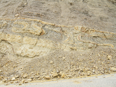
Along the old Ridge Route, north of Castaic, you will find evidence of wild geologic forces in the hills, such as the folds in this rock above. (Photo: K.Anderberg, Jan. 2008)
"Nowhere else in the world can you encounter more scenic thrills than traveling the Ridge�" - L.A. Times, April 30, 1922
I have created a webpage about the Ridge Route at http://users.resist.ca/~kirstena/pageridgeroute.html. "A twisting road along the scenic Castaic Mountains, that boasts of 1136 turns in the 28 miles of its length, offers a ride that for sheer beauty and magnificence cannot be equaled in the United States. The feature of this trip�is the beautiful view which is enjoyed from the winding highway on the crest of the Castaics�For the entire length of the range, one may enjoy scenic vistas, panoramas, and broad sweeps of mountain majesty which will live forever in the memory. Only a light sagebrush covers the desert Castaics. The mountain formation is volcanic and the rich colorings of deep reds, purples and yellows are greatly enhanced by sunset." - L.A. Times, April 30, 1922
The old Ridge Route, pictured above, was given a budget for a survey of the route in 1895 (L.A. Times, Oct. 23, 1895, p. 8), and then it was built in 1915 (L.A. Times, Oct. 30, 1933, p. A1). It was a travel route from the Santa Clarita Valley north, that was widely used in the 1920's and 30's. A trecherous road, full of windy bends and blind curves,
straddling high hilltops, the route is novel and historic today. When you begin to drive up Ridge Route today, heading north from Lake Hughes Road in Castaic, you will soon
find yourself alone in a quiet land. The hills go on and on, and when it is really quiet, you can hear cows mooing as they graze far across the valley. The Ridge Route is still
quite a spectacular drive, with many of the original sights that lured in traffic long ago. The I-5 interstate now runs the route that Ridge Route used to with more efficiency,
so Ridge Route is virtually empty most of the time now. (Photo: K.Anderberg, Jan. 2008)
This is a picture I took from the Ralph's parking lot in Castaic during the 1997 (?) wildfires...The ridge lines would glow orange at night as these fires raged.
The Interstate Freeway (I-5) was shut down at Lake Hughes Road, right at Castaic. We finally got home in a traffic jam in I-5 this day...I remember we had things packed in case
we had to evacuate and ashes were everywhere like rain. I have memories of raging wildfires in Santa Clarita since I was very young. I remember a fire coming very close to our
house on Guadilamar Dr. in Saugus when I was about 3 years old. My dad took me up on the ridge to look below at the flames licking up all that chapparel in its path...The
Castaic recreation area includes
sports such as fishing, boating, water skiing, swimming, etc. (Photo: K.Anderberg, late 1990's)
The Old Road, or the old Highway 99:
The January 25, 1994 issue of the Santa Clarita Valley Signal newspaper shows not only the collapsed freeway overpasses in the area, but also details how Newhall was
feeling the aftershocks quite heavily...(Photo: K.Anderberg)
Kirsten Anderberg. All rights reserved. For permission to reprint/publish, please contact Kirsten at kirstena@resist.ca.


 Kirsten Anderberg. All rights reserved. For permission to reprint/publish, please contact Kirsten at kirstena@resist.ca.