Kirsten Anderberg/The Sylmar Earthquake: February 9, 1971
My First Serious Quake Experience
By Kirsten Anderberg
On Feb. 9, 1971, the San Fernando Valley had a 6.6 earthquake that collapsed freeways and hospitals and broke the Van Norman Dam located to the north of Rinaldi in Granda Hills.
LOOK FOR KIRSTEN'S NEW BOOK ABOUT EARTHQUAKES DUE OUT IN FEB 2012!
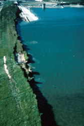
In this picture, the U.S.G.S. photographed pieces of the dam wall falling into the Van Norman Dam...(Photo: US Geologic Survey) During the quake,
the top 20+ feet of the concrete dam sides slid into the dam, leaving only 4 feet between the water and the Valley
below. At the time of the quake, the dam was holding 14 feet less water than normal, and thus luck once again came through. There was a 2 foot wave reported in the dam due to the landslide as well.
You can see from this picture just how close that dam is to suburban Los Angeles, and you can also see how close that water is to the top in this photo.
You can see an interesting video with great footage of the dam collapse and evacuation, the tragedies at Olive View and the Veterans' Hospital, etc. on You Tube by
clicking here...
I took this picture of the old Van Norman Dam basin in January 2008 from the west side of the Odyssey Restaurant parking lot. You can see on the left, the original wall for the dam which broke in the
picture above. The dam was moved back to prevent a similar threat in the future from the dam after the '71 quake. You can see the new dam wall in about the middle of this photo,
it is the white wall between two hills. The old dam floor is seen in this picture, dry, with new roads, buildings, etc. on it. The area is not open to the public and is considered
a drain basin for the dam in an emergency so no permanent homes, etc. lie on the old basin floor.
I was 10 years old when the Sylmar quake hit Mission Hills, CA, a suburban community in the San Fernando Valley (Los Angeles County). The experience started a lifelong
interest in quakes for me. 80,000 residents of the San Fernando Valley floor had to be evacuated for 4 days while the Van Norman Dam (or Lower San Fernando Dam) at the north end of the Valley (just
behind our house) was drained. The sides of the dam had cracked and slid into the dam, and the water had begun to leak through cracks in the dam walls, threatening the
Valley floor below. We used to go up to the Odyssey Restaurant parking lot and look over the western edge, to watch the progress as the dam was breaking.
For more of Kirsten's experiences in this quake, watch for her new book about earthquakes due out in Feb. 2012.
Kirsten Anderberg. All rights reserved. For permission to reprint/publish, please contact Kirsten at kirstena@resist.ca.

 In this picture, the
 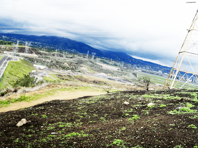 I took this picture of the old Van Norman Dam basin in January 2008 from the west side of the Odyssey Restaurant parking lot. You can see on the left, the original wall for the dam which broke in the
picture above. The dam was moved back to prevent a similar threat in the future from the dam after the '71 quake. You can see the new dam wall in about the middle of this photo,
it is the white wall between two hills. The old dam floor is seen in this picture, dry, with new roads, buildings, etc. on it. The area is not open to the public and is considered
a drain basin for the dam in an emergency so no permanent homes, etc. lie on the old basin floor.
I took this picture of the old Van Norman Dam basin in January 2008 from the west side of the Odyssey Restaurant parking lot. You can see on the left, the original wall for the dam which broke in the
picture above. The dam was moved back to prevent a similar threat in the future from the dam after the '71 quake. You can see the new dam wall in about the middle of this photo,
it is the white wall between two hills. The old dam floor is seen in this picture, dry, with new roads, buildings, etc. on it. The area is not open to the public and is considered
a drain basin for the dam in an emergency so no permanent homes, etc. lie on the old basin floor.
 Kirsten Anderberg. All rights reserved. For permission to reprint/publish, please contact Kirsten at kirstena@resist.ca.